
Walk a Huntington Street Directory
Begin with one complete Huntington address and preserve its source wording. The West Virginia assessment search can connect a physical address to a Cabell parcel and an assessed owner. The county map adds shape and boundary context. The deed index then tests the ownership trail. Voter and directory records may add a dated residence listing, but their access and meaning differ. This street directory method moves from a place to records without turning an owner, taxpayer, or applicant into an unsupported claim about current occupancy.
- Normalize the number, direction, street type, unit, and ZIP, while also saving the original spelling.
- Search the assessor by physical address and record the parcel ID, tax year, owner label, and deed book/page.
- Open the GIS viewer to confirm the parcel, city boundary, street relation, and map layer date.
- Use the Cabell Clerk index to read the cited deed and follow any prior instrument.
- Check a voter record only through its lawful channel, then use dated directories for historical household evidence.
The best result is a set of labeled relationships: assessed owner, tax-mail recipient, physical parcel, deed party, permit applicant, voter record, or historical directory entry. Those labels keep a by-address search honest. If the street name alone produces too many parcels, narrow by map, parcel, district, tax year, or book/page.
Write the lookup date beside every result. Assessment ownership can lag a recorded transfer, and a voter status can change after the nightly update. When two sources disagree, do not choose the one that looks newest. Compare their effective dates, then ask the responsible custodian which update cycle or instrument controls the narrow question. This practice is especially useful for estates, trusts, and parcels with more than one owner label.
Search Huntington Parcels by Address
The statewide property form is the strongest public starting point for a Huntington street directory search. It supports basic parcel discovery, sales and appraisal filters, advanced property details, and prior ownership. The live service does not publish an online beginning year, so an empty result cannot settle an older question.
| Field group | Useful inputs | Keep from the result |
|---|---|---|
| Basic | Owner, street, parcel, map | Parcel ID and physical address |
| Appraisal and sales | Sale date, deed book/page, value | Tax year and recorded-deed lead |
| Advanced | Class, land use, acreage, building year | Assessment labels, not occupancy |
| Prior ownership | Former owner and transfer context | Dated lead to verify in the deed |
Huntington Address Labels Differ
A parcel card can hold three address ideas at once. The mailing address is where tax notices go. The physical or situs address identifies the taxed site. An E-911 address serves emergency-location needs. They may differ, and that difference is not an error by itself. It can reflect an owner who receives mail elsewhere, a corner parcel, or separate address systems.
- Parcel
- A mapped unit used for tax and land records.
- Situs address
- The physical location assigned to the parcel, distinct from tax mailing.
- Plat
- A recorded map showing lots, lines, and related land details.
- Criss-cross directory
- A historical directory arranged by street or number instead of only by surname.
Open the official sample parcel detail that demonstrates the separate fields.
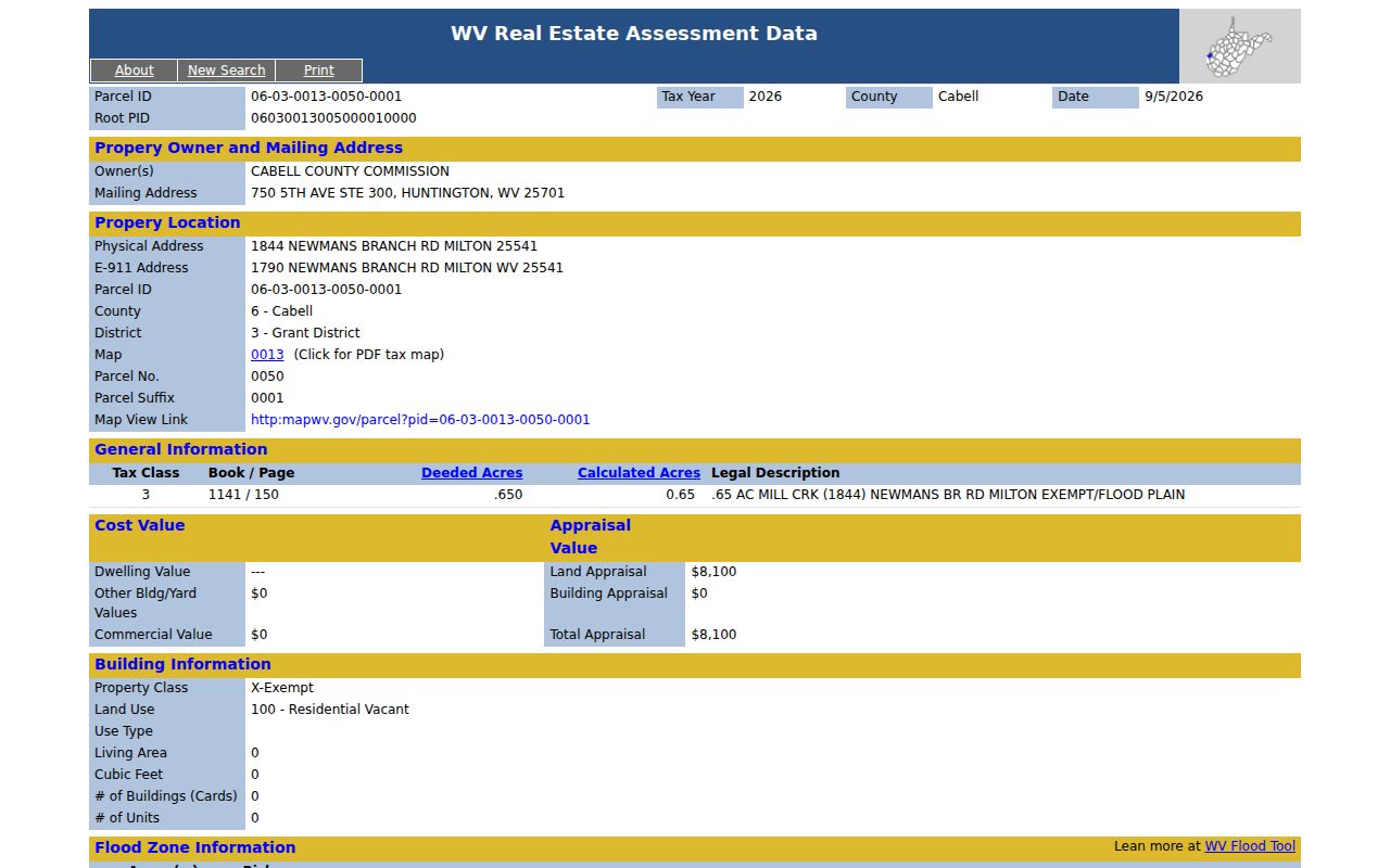
The sample is useful as a field lesson, not as a model for publishing a private profile. A Huntington street directory should reproduce only what the research task needs.
Map Huntington Streets and Boundaries
The Cabell Assessor GIS viewer supplies spatial context after the parcel search. Use it to see parcel shapes, nearby street numbers, and adjacent tracts. The city boundary comparison service separately exposes Cabell parcels, zoning, Census in/out, and a HuntingtonCityBoundary2026 layer. Capture the active layer and date. A basemap line is helpful context, but it is not a deed or a final legal boundary ruling.
Huntington also has a small Wayne County relationship. A Huntington mailing label therefore does not guarantee Cabell custody. The city offers parcel prefixes 05, 06, and 07 as an inside-city clue, yet the research calls for a GIS cross-check. If the county changes, so does the clerk, assessor, and deed trail.
Huntington Street Records Compared
No official Huntington street directory combines all address records. Cabell and city custodians keep different series, each with its own role and access path. Use this coverage table to choose a source based on the question, then retain its date and relationship label.
| Record Set | Keeper | What It Shows | Access |
|---|---|---|---|
| Assessment and tax | Cabell County Assessor | Owner label, mailing and physical address, parcel | State search, county site, counter, phone |
| GIS parcel map | Cabell Assessor and city GIS | Parcel shape, zoning and boundary context | Public viewers and office help |
| Deeds and liens | Cabell County Clerk Record Room | Parties, legal description, book/page, instruments | Online index, counter, phone, mail, certified copy |
| Voter record | WV SOS and Cabell County Clerk | Dated registration status and district data | One-person lookup, controlled list request, office terminal |
| Permits and zoning | City of Huntington | Service address, application, permit type | Tyler portal, department, city FOIA |
The parcel number links an assessment to mapped land. Book/page or instrument number carries that lead into the deed. A service address can locate a permit, while a name and birth date are required for the state voter status tool. The public voter file excludes phone, email, Social Security, driver-license, and nonoperator-ID numbers. List access is noncommercial under West Virginia law.
The state voter-status lookup asks for first name, last name, and date of birth. It is designed for a one-person status check, not browsing every house on a Huntington street. Data reflects the latest county entry and updates nightly. For a correction, county election question, or permitted list, contact the Cabell County Clerk. A separate data-services request controls defined list access, format, sorting, and lawful use. City election and precinct questions may instead require the Huntington City Clerk. These access paths should never be collapsed into a downloadable household roster.
Deeds Behind Huntington Addresses
The Cabell County Clerk record room searches recorded instruments by date, grantor or grantee role, record family, document type, instrument, and book/page. A grantor gives an interest; a grantee receives one. Read the image when available because the index is only a pointer. The legal description and references to prior deeds are often more stable than a street address.
When the portal fails or an older deed is absent, contact the Recording/Record Room at the Cabell County Courthouse, Suite 108, 750 5th Avenue, Huntington. The office is listed Monday through Friday, 8:30 a.m. to 4:30 p.m., at 304-526-8625. Staff can explain copy choices, older books, and certified-copy needs. Mail, phone, fax, counter service, a precise county FOIA request, and the State Archives are documented fallbacks.
Cabell's archival deed index spans 1808 through 1968, but named gaps affect grantor Sm-Sz, T-U-V, W-X-Y-Z and grantee D for 1808 through 1922. Search the deed book or related land book rather than treating those empty slices as proof.
The Archives also lists deeds from 1809 through 1901 and land books from 1809 through 1900. Those dates describe preserved historical series, not the live portal's coverage. For an early Huntington parcel, give archive staff the names, approximate year, book/page if known, and legal description. A focused request has a better chance than asking for every record tied to one surname.
Huntington Permits by Service Address
The city's Tyler permit portal supports public searching by service address, permit number, and permit type. A result can document an application or work tied to a site. It does not name every occupant, prove that approved work occurred, or establish present use. Save the permit number, type, date, and status before drawing a narrow conclusion.
Planning and Zoning provides the zoning map, ordinance, boundary help, plan review, and sign or site-plan routes. If no portal record answers the question, call the responsible city department or send a focused West Virginia Freedom of Information Act request to the city custodian. Ask for one address, permit type, and time range.
Older Huntington Streets Need Context
Past address work adds city directories, newspapers, and maps. The State Archives directory list has selected Huntington editions from 1913 through 2016, not an unbroken annual run. Cabell County Public Library staff will search one person for no more than five directory years and may supply surname pages if no entry appears. For the collections themselves, use the Huntington city directories page.
Keep a historical spelling alongside the normalized one. Test directionals, numbered streets, and "avenue" versus "ave." A place may also appear as Guyandotte, Central City, West Huntington, or under a mailing label that does not match a modern line. No authoritative Huntington street-renaming or renumbering list was found in the reviewed sources, so do not invent a conversion.
Note: A missing edition or unindexed spelling means only that the checked holding produced no result.
Huntington Buildings on Sanborn Maps
Sanborn fire-insurance maps add a building timeline without claiming a resident. Huntington sheets are documented for 1884, 1889, 1893, 1898, 1904, and 1931. They can show a structure footprint, use, construction clues, and the street grid at the map date. Pair that evidence with a deed and directory rather than reading a map as a household list.
Limits of Huntington Street Lookups
A street directory cannot promise a full or current household. An assessment is a tax record, a deed is a conveyance, and a permit names a project relationship. GIS shows land. USPS confirms postal formatting but expressly does not prove that a person or company is at an address. Utility customer details can be exempt, DMV data is restricted, and the West Virginia Address Confidentiality Program protects a participant's real location behind a substitute address.
Publicly indexed information is not unrestricted material for republication. Keep only the fields needed for lawful personal research, civic review, seller verification, or family history. For an error, use the custodian's correction route. Never work around a redaction by joining other sources.
Commercial reverse-address results may be stale or joined from unclear sources. Use them only as unverified leads, then return to the Huntington custodian that created the parcel, deed, permit, or voter record. An official index is still not the same as a certified copy, and neither automatically establishes who lives at the site.
Lawful use. Use Huntington address records only for lawful personal purposes. Never use a street lookup to stalk, harass, intimidate, or expose a protected person.